


emparis

m@nu
User
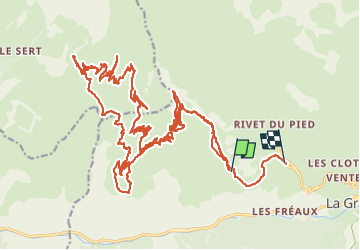

Length
42 km

Max alt
2535 m

Uphill gradient
1694 m
Km-Effort
66 km

Min alt
1737 m

Downhill gradient
2094 m
Boucle
No
Creation date :
2023-01-28 10:54:01.055
Updated on :
2023-01-28 16:32:19.337
5h37
Difficulty : Very easy

FREE GPS app for hiking
 SityTrail
IGN / Geographical institutes
SityTrail Plus
The world is yours!
About
Trail Touring skiing of 42 km to be discovered at Provence-Alpes-Côte d'Azur, Hautes-Alpes, La Grave. This trail is proposed by m@nu.
Positioning
Country:
France
Region :
Provence-Alpes-Côte d'Azur
Department/Province :
Hautes-Alpes
Municipality :
La Grave
Location:
Unknown
Start:(Dec)
Start:(UTM)
284648 ; 4992483 (32T) N.
Comments